🔴 Website 👉 https://u-s-news.com/
Telegram 👉 https://t.me/usnewscom_channel
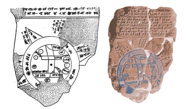
The Babylonian Map of the World, often referred to as the Imago Mundi, is a fascinating artifact from ancient Mesopotamia, dating back to the 6th century BC. This clay tablet, now housed in the British Museum, offers a detailed representation of how the Babylonians viewed their world, combining geographical knowledge with mythological concepts.
At the center of the map is the city of Babylon, depicted as a rectangle with radiating lines representing key cities and regions, such as Assyria and Elam. The Euphrates River, essential to Babylonian civilization, flows through the map, connecting various regions. The map is enclosed within two concentric circles, symbolizing the boundaries of the known world, with the space between the circles representing the vast, uncrossable ocean.
Beyond the ocean lie eight triangular or wedge-shaped regions, called “nagu” in the cuneiform text. These areas represent distant lands or mythical places, reflecting the Babylonians’ belief in a world filled with mysterious and inaccessible realms. The inscriptions describe these regions as exotic and dangerous, with references to fantastical creatures and phenomena, such as giant scorpions or eternal darkness. One such region is described as a land where “a bird is born without wings,” suggesting a place of unusual natural occurrences.
The recent discovery of a missing fragment from the map has shed new light on these enigmatic regions, revealing descriptions of places like “The Great Wall,” which some scholars believe could be an early reference to the Zagros Mountains or other formidable natural barriers. The blend of real geography with mythical elements illustrates the Babylonians’ attempt to make sense of their world, combining empirical observation with religious and cultural beliefs.

Top image: Left; Drawing by B. Meissner in Babylonien und Assyrien, 1925. Right; Babylonian Map of the World with false color. Source: Left; Bruno Meissner/Public Domain, Right; FlorinCB/CC0